SantaFe.live: Every Pixel Has an Address, a Digital Acequia for Santa Fe's Shared Photographs, Maps and Stories
Abstract
Santa Fe has always been a crossroads. The Old Santa Fe Trail met the Camino Real here. Artists, scientists, technologists, and spiritual explorers have gathered here for generations.
Spanish colonists, Pueblo peoples, the Church, Mexican families, and waves of new arrivals have layered their lives onto these same streets, hills, and waterways. Every person has a story. The result is one of the most culturally rich and complex histories of any small city in the Americas. Yet that history lives scattered across shoeboxes, family albums, newspaper archives, historical maps, home videos, institutional collections, and social media feeds. We share photographs on Facebook and Instagram, but these platforms scatter our collective memory across disconnected posts with no way to stitch stories together across contributors, query images for the subjects we care about, or keep certain photographs private to family and trusted circles.
This project is being developed with his team at Santa Fe native companies Redfish Group and SimTable, in collaboration with Peter Weiss, local historian and tour guide, whose deep knowledge of Santa Fe's layered past anchors the technology in the stories that matter.
The Technology
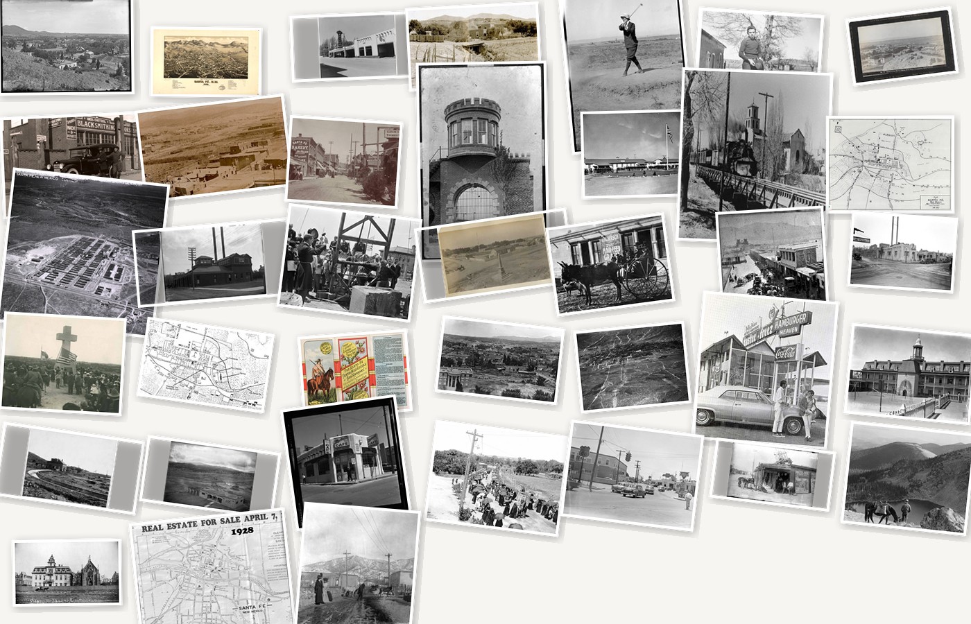
The Santa Fe Digital History Project (SantaFe.live) is a free, open platform managed as a commons by the community. It offers a different approach. Given any photograph, old or new, we can figure out exactly where the camera was standing, which direction it was pointing, and what it was looking at on the landscape. Once we know that, every pixel in the image gets a real-world address: a latitude, longitude, and altitude on the hills, walls, and streets of Santa Fe.
A photograph from 1912 and a photograph from 2024, taken from the same stretch of road, can be layered on top of each other so you can watch the city change. As more photographs are contributed from different angles and different eras, they collectively build a three-dimensional model of Santa Fe's buildings and landscape that evolves through time: a living reconstruction of the city that grows richer with every image the community adds.
Each story becomes a thread, combining spatially anchored photographs, old maps, and newspaper archives into a narrative anyone can follow. The Santa Fe New Mexican's archives, searchable back to 1860, and the Palace of the Governors Photo Archives give us extraordinary institutional foundations to build on. Layer in family collections and community contributions, and the threads multiply.
Threads waiting to be woven: the Chile Line railroad running through town, the army hospital on what became the College of Santa Fe campus, Route 66's path down Water Street before the I-40 diversion, the acequia system that once threaded through downtown, Canyon Road's transformation over a century, the evolution of the Plaza, circuses in Santa Fe, the Cross of the Martyrs, the hidden cemeteries, a family's homestead through five generations. When these threads are woven together, they form our collective tapestry of shared history.
Community-Powered, Community-Governed
The platform is community-powered. Contributors decide what is public, what stays within a family group, and what remains entirely private. The devices we already carry, our phones and laptops, can serve as the hosts. We do not need to centralize our memories on the cloud.
Rather than uploading our digital heritage to the feudal clouds controlled by Google, Apple, Facebook, and the AI companies, we can share directly from our own devices with the privacy and control we choose, and govern our collective commons the way our ancestors governed water: as a digital acequia, the centuries-old community irrigation system where shared resources flow through infrastructure the community owns, maintains, and governs together.
Most importantly, this is a tool for discovery. Let our youth explore history spatially, find the connections between stories, and construct their own narratives instead of being told them.
This talk will demonstrate how the technology works, show early examples, and invite the Historic Santa Fe Foundation community to help build this living record together.
About the Speaker

Stephen Guerin is a Senior Teaching Associate in Landscape Architecture at Harvard's Graduate School of Design and a Research Associate at the Harvard Visualization Research and Teaching Laboratory. He is CEO of SimTable LLC, whose wildfire and emergency management simulation systems are deployed throughout Santa Fe and New Mexico, across 35 states, and in Europe and Australia, serving over 300 agencies including CAL FIRE and Texas A&M Forest Service. From 2005 to 2018 he served as faculty at the Santa Fe Institute's Complex Systems Summer School. Stephen came to Santa Fe in 2000 for the science of complexity and stayed for the culture and the skiing. With his wife Alison, he raised his two boys, Miles and Reed, "born here all their life". He built the Santa Fe Digital History Project from his belief that the same technology used to understand wildfire landscapes can anchor a community's historical memory directly onto the places where that history unfolded.